Success Story
Daffodil helps an urban planning firm to leverage AI and detect surface water bodies from geo-spatial data
Services Used:
About the Client
Green City Watch is a geospatial AI firm specializing in urban ecological engineering. It leverages the Industrial Internet of Things (IIoT) technology to empower municipalities and local councils with data-driven urban ecology. Green City Watch empowers 30+ (mega)cities, from Boston to Amsterdam to Jakarta, to understand, monitor, and improve their urban forests through data-driven decision-making. Their TreeTect™ technology provides municipalities and urban foresters with a better overview of their tree inventory. By combining Industry 4.0 technologies with satellites, LiDAR, and drones, TreeTect™ allows municipalities to draw actionable insights about green space in near real-time.
- >90% precision
- 11 machine learning models trained
- 30+ cities mapped
The Situation
Jakarta city in Indonesia is known for its lakes. However, environmental disturbances such as lake filling, land use change, garbage dumps, shoreline encroachment, etc. have caused the loss of urban lakes. Focussing primarily on two types of surface water bodies- lakes and rivers, the Government of Indonesia and the World Bank, in collaboration with Green City Watch, took the initiative to safeguard these surface water bodies from loss.
One of the prime steps in this initiative was to identify the lakes in the Jakarta region and their stress levels over the years. To automate this task, Green City Watch (GCW) wanted to build a Machine Learning model that could do the following:
- Identify and mark different water bodies in different seasons
- Measure stress levels (sedimentation load) in the water bodies
- Discover the change in water bodies over a period of 35 years
The Solution
To start with, team Daffodil worked on creating a data set that is comprehensive and reliable to provide a high accuracy rate. Moreover, the most suitable technique for model training was identified that’s capable of accurate predictions for existing, new, or unforeseen data.
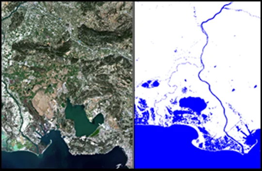
For model training, the image segmentation technique was utilized to identify water bodies and measure their stress levels. Image segmentation is one of several fields in Machine Learning where a model is trained in such a way that it can identify objects at the pixel level and classify it. This helps to accurately extract the objects of interest from the image.

Model Training:
For training the models, the semantic segmentation technique was utilized. It refers to the task of assigning a class label to every pixel in the image. This way, a model treats multiple objects from a single class as a single entity.
Data Set:
For the data set, Green City Watch had Satellite imagery from World View 1 in the TIFF format. Since the TIFF are detailed and has a lot of metadata stored, it’s usually large in size. Thus, the images were converted into JPEG format (which is less complex and has only 3 bands and spectral indices).
Moreover, several measures were taken to remove noise from the data set. Atmospheric correction (such as removing excessive clouds from imagery), identifying gaseous components, converting large-sized images into grids, etc.

Water Boundaries Detection:
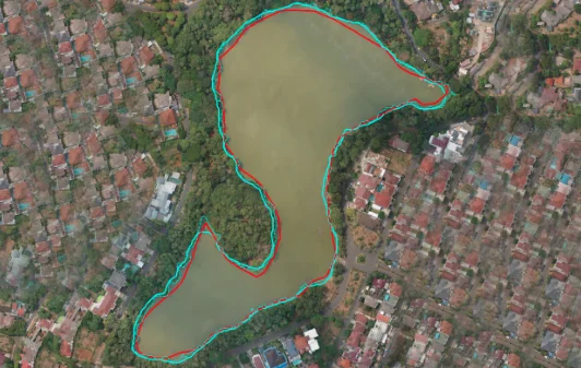
For detecting the boundaries of the water bodies, Normalized Difference Water Index (NDWI) was calculated. It differentiates the water from the dry land and is most suitable for water body mapping. An ML model with a given and augmented data set was developed with 95% accuracy in detecting the surface water bodies.

The Impact
The client has been extremely satisfied by the way Daffodil has executed its vision and has planned for further updates to the system. The water body detection technology provides municipalities and urban planners with a better overview of water bodies, their health and water levels. By combining Industry 4.0 technologies with satellites, LiDAR, and drones, the solution allows municipalities to draw actionable insights about gwater space in near real-time.
Read Related Case Studies
Get in Touch
Sign up for a 30 min no-obligation strategic session with us
Let us understand your business objectives, set up initial milestones, and plan your software project.
At the end of this 30 min session, walk out with:
- Validation of your project idea/ scope of your project
- Actionable insights on which technology would suit your requirements
- Industry specific best practices that can be applied to your project
- Implementation and engagement plan of action
- Ballpark estimate and time-frame for development


